Thursday 18 December 2014

Taxed O2 in 2050

Taxed O2 2050:  When Rural People will get paid for their love to Nature.

2014 is going to end, civilization and industrialization has new heights, and people still are running blindly towards the technology and development with avoiding the hand of the nature and missing the reality of prediction. Increased industrialization and growing population influences the increased rates of urbanization, which is leading to decrease in natural vegetation and preparing a way to enhance artificial vegetation and genetically modified trees, in turns of flowering, coconut tree, some bushes, and even the large trees.
The loss of natural vegetation and playing with nature it is very important question to think that where it would lead us?  Think about it, the speed at which civilization is growing, it becoming guilty at the same speed to be responsible to modify it earth’s ecosystem. Well on the other hand if we are continuing the same till 2050, I can imagine the scenario when there will be shortage of O2 and government will be bounded to apply tax on the O2 consumption, imagine that fact…. Number of family members will multiply the taxes, and the number of green vegetation infront of their homes will be counted to deduct the tax amount. Can you imagine the fact that it would be a dramatic change, when poor farmers and rural families will be getting paid for maintaining their surrounding full of green vegetation and will get an O2 tax relaxation? See that there will be decline of current prestige civilization which has a poor heart for rural people and their living standard, although they need to be grow, yes its necessity but not in exchange of their rural extant and their moral values. Rural people if failed to stand at the same place at where current middle class and upper middle class people are, then it’s not a concern to worry one day they will have to pay for their simplicity and love for nature. Wait till the 2050, when their ambitions will lead them at this stage, “Taxed O2

A thought of my fiend Abhishek Pundir, and documented in my way….. Hope it will be liked from you.

Monday 15 December 2014

Moisture Variation In Soils

Moisture Variation In Soils: In Relation to Surface Albedo

Studies in the past illustrated the effect of soil moisture content over the surface albedo, which are inversely related, i.e., surface albedo decreased with increasing surface soil moisture content. Among them, Idso (1975) found surface albedo to be a linear function of soil moisture content at the very thin surface layer (0–2 cm), and surface albedo corresponded slightly to the soil moisture of more than 2 cm depths. Additionally, he pointed out that the variation of bare soil surface albedo with time was symmetrical about local noon when the soil was rather wet (volumetric soil moisture content >0.20V V-1) and rather dry (volumetric soil moisture content <0.04V V-1). Another study measured the soil moisture of 0–2 cm at the soil surface, and found that the soil moisture content was less than 0.0075 g g-1 in dune sand with soil bulk density of 1.665 g /cm-3 and BSCs with soil bulk density of 1.386 g cm-3. The surface albedos exhibited random variations with increasing soil moisture content and no significant relationship was found between surface albedo and soil moisture content when the soil moisture content was less than 0.0075 g g-1. Gu et al. (2001) assumed that the surface was in dry conditions when the surface soil moisture was less than 0.005 g g-1 and Idso (1975) proposed a volumetric soil moisture content of less than 0.04V V-1.We consider the surfaces as dry and soil moisture has little influence on surface albedo when soil moisture is less than 0.0075 g g-1. Thus, by reviewing the control factors on surface albedo, it is assumed that surface albedo is predominantly controlled by solar zenith angle for the two bare and dry surfaces.

Friday 5 December 2014

Aerosols: A perception Regarding to Climate change

As we all know about aerosols, let me first start with the question that what are these particles? Do they have direct effect on climate change? Or they indirectly affect it?

Here we go; Aerosols are the tiniest particles which remains suspended in the atmosphere, most specifically in the lower atmosphere or troposphere. Different specialists describe the particles based on shape, size, and chemical composition.
Climatologists typically use another set of labels that speak to the chemical composition. Key aerosol groups include sulfates, organic carbon, black carbon, nitrates, mineral dust, and sea salt. In practice, many of these terms are imperfect, as aerosols often clump together to form complex mixtures. It’s common, for example, for particles of black carbon from soot or smoke to mix with nitrates and sulfates, or to coat the surfaces of dust, creating hybrid particles (1).

These particles keep moving in atmosphere and interact with atmosphere in two ways; directly and indirectly. Direct interaction with atmosphere leads to generate the blue sky, and another colors in different events, like reddish and yellowish color at the time of sunset and sunrise, we all know that this is due to scattering of incoming sun's radiation in atmosphere. In true words these aerosols are capable of reflecting back the sun's radiation in a large extent which leads to decrease in the temperature or truly speaking retards to enter it into the our atmosphere. Whatever we talked about was only the thing which can observe with our senses, and we technically admire it. But the indirect interaction is quit complex phenomena, hard to understand, but it's true too, that aerosols affects the formation of clouds in lower atmosphere. The amount of aerosol present in lower atmosphere, modifies the reflectivity of clouds to sun light, also changes the size of cloud in lower atmosphere.
Aerosol Interaction with cloud and ozone deterioration
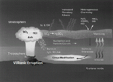

Aerosols are also responsible for deterioration of stratospheric ozone, which is due to its chemically reactive property. How this happens it’s a complex chemistry, what we can understand is that it chemically react with the atmospheric water which may be available as water vapor, this leads to formation of chemically active clouds which generates the highly active chlorine which react with the ozone. Well this is a complex thing. Another thing is to notice that what are the other impacts of aerosols? Aerosol may cause acid rain due to the presence of chemically active particles which forms acids; these may be SO2 or HCL which is generally erupted by volcanic movements. These aerosols when comes in contact with water, rains as acid rain mainly in the form of hydrochloric acid and sulfuric acid.

Now question rises that where from these aerosols come, actually aerosols are the part of our nature hence the atmosphere too. Nature itself carries these particles in suspension, but some of the aerosols are added to our atmosphere by man's activities.
The main sources of aerosols are:
1. Desert Dust
2. Volcanic Eruption added
3. Man Made
As i mentioned above that nature itself carry the aerosols, about 90% of by mass of aerosols are naturally originated and added to the atmosphere. Volcanic eruption is the one of the major natural phenomena which introduces huge amount of ash into air, SO2 and other gases which yields sulfates. Naturally occurring forest fires, introduces lot of organic carbon. Some plants produce gases that react with other substances in the air to yield aerosols, such as 'smoke' in the Great Smoky Mountains of United States. Likewise in the ocean, some types of micro-algae produces a sulfurous gas called dimethyl sulfide that can be converted into sulfates in the atmosphere(1). Sea salts which vaporized with water, most abundant aerosols. Sand particles are also present in huge amount added by the high speed winds.
Rest amount of aerosols are considered to be added by anthropogenic activities, having a great variety. Mainly these are added by the industrial activities, due to fossil fuel combustion which induces large amount of sulfur-di-oxide. Other activities like consuming farm waste, preparation of farm land yields smoke, which is a source of organic carbon.
Automobiles incinerators, smelters, and power plants are prolific producers of sulfates, nitrates, black carbon and other particles. Deforestation overgrazing drought and excessive irrigation can alter the land surface, increasing the rate at which dust aerosols enter the atmosphere. Even indoors, cigarettes, cooking stoves, fireplaces, and candles are source of aerosols.

Aerosols and sunlight:
Different type of aerosols scatters or absorbs sunlight in different proportions, depending upon the physical properties (shape, size etc.). It is a direct effect of aerosols, which directly deal with earth’s radiative field. Mostly aerosols reflect back the sunlight depending upon their color and composition, but some darker aerosols absorb it too.
Pure sulfates and nitrates reflect nearly all radiation they encounter, cooling the atmosphere. Black carbon, in contrast, absorbs radiation readily, warming the atmosphere but also shading the surface. Organic carbon, sometimes called brown carbon or organic matter, has a warming influence on the atmosphere depending on the brightness of the underlying ground. Dust impacts radiation to varying degrees, depending on the composition of the minerals that comprise the dust grains, and whether they are coated with black or brown carbon. Salt particles tend to reflect all the sunlight they encounter (1).
If amount of aerosols suddenly increased in the atmosphere; than it cause sudden cooling effect. Aerosols, particularly black carbon, can alter reflectivity by depositing a layer of dark residue on ice and other bright surfaces. In the Arctic especially, aerosols from wildfires and industrial pollution are likely hastening the melting of ice.
Scientists believe the cooling from sulfates and other reflective aerosols overwhelms the warming effect of black carbon and other absorbing aerosols over the planet. Models estimate that aerosols have had a cooling effect that has counteracted about half of the warming caused by the build-up of greenhouse gases since the 1880s. However, unlike many greenhouse gases, aerosols are not distributed evenly around the planet, so their impacts are most strongly felt on a regional scale.

Aerosols and clouds:
Aerosols play a critical role in the process of cloud formation. In fact, most clouds formed due to the presence of aerosols which serves as the tiny “seeds,” called cloud condensation nuclei.

Natural aerosols—often sulfates, sea salt or ammonium salts—are the most common condensation nuclei in pristine environments. Polluted air, in contrast, usually contains much higher concentrations of water-soluble particles, which means pollution-rich clouds tend to have more numerous, but smaller, droplets. The small droplets make polluted clouds look brighter than they would otherwise be. Just as many bits of crushed ice give light more surfaces to reflect off—appearing brighter than a solid cube of ice—if the water in a cloud is divided into a larger number of smaller droplets, it will scatter more light and become more reflective(1).

Brighter clouds, in turn, block sunlight from reaching Earth’s surface, shading the planet and producing net cooling. This cloud brightening effect—called the “cloud albedo effect”—may have a big impact on the climate, though only in recent years has it been possible to start quantifying the effect.
This impact of aerosols is clearly visible in ship tracks, bright streaks in marine clouds that look like airplane contrails. In the absence of ships, sea salt particles and the natural sulfates produced by phytoplankton seed most marine clouds. However, the exhaust from ship smokestacks make trails of sulfates and other aerosols that form long, bright clouds.

Concluding part of this text is that presence of aerosols in lesser of higher amount, modifies the  climatic changes over an region.

Sunday 23 November 2014

Surface Albedo As a tool of Estimation of Temperature

Surface albedo as, i already mention in my recent post that it a measure of surface reflectivity over earth surface. It may give us and prediction about the future temperature changes over an area. 
Landsat

Surface albedo if correctly documented if may serve as an important tool of estimating surface energy balance which is helpful in understanding the temperature rise trends over a region. Although surface albedo itself, is a very difficult phenomena to measure because of variation in temporal and spatial context. Varying terrain profile like steep and multiple slopes and flat surfaces makes it is more complex, also the elevation of a region also alters reflectance due to associated atmospheric transmissivity characteristics than lower elevations. 

Yeah! In real words actually it is a very difficult task to estimate the surface albedo and to correlate it with the temperature rise. Here i am illustrating an estimation methodology which is based on the certain assumptions; they are
1. Assume the earth surface as "Lambertian surface" with equal reflectance of direct and diffuse irradiance 
2.  Vegetative cover over that study area should be same in nature (must have same vegetation canopy) 

Keeping above assumptions in mind if we proceed for estimation of surface albedo, then we have to necessary requirements 
1. Estimation data
2. Methodology 
Data required for estimation purpose are satellite imagery, and associated DEM for the same study area. By using the satellite image processing technique we can analyze the images to characterize the surface albedo. If we choose Landsat Thematic Mapper data for this purpose then we have two problems 
1. Sensor has only limited off-nadir pointing capability
2. It does not provide the continuous sensitivity to the entire solar spectrum.
When going for measurement of surface albedo one should keep in mind the some correction for topography and atmosphere. 

Procedure:
1. Geo-referencing of satellite images to the UTM using nearest neighbor technique. 
Original and supervised classified image
2. Classification of image (supervised or unsupervised)
3. Calculation of in band reflectivity  
4. Extrapolation of broad band albedo
After understanding the above method, one can calculate the surface albedo. The method includes procedure for atmospheric correction, topographic normalization, and extrapolation of broad band albedo from narrow band satellite measurements which is only mention above for detailed study one can refer various articles and literature. Above method cannot be applied for non Lambertian Surfaces. Angle of illumination effect on various vegetation canopies is different. And may or may not have pronouncing effect on a particular type of vegetation canopy. Like in comparison of alpine tundra vegetation, agriculture vegetation canopy have more pronounced effect. 

Estimation the surface albedo over a region and by calculating the changes in the different land cover uses over a particular area, we can also correlate the surface albedo to the changes in the temperature.


Thursday 9 October 2014

Climate in India's perspective: "Save The Climate and Bring Back to It's Original"

A issue in present world, which must caught fire is climatic changes, thus the global warming becomes the most considerable phenomena, although it is not a new one to hear about, from past few decades every one talked about it and wrote also, but now it is a time take action and bring our steps ahead to save our climate and indirectly to our future. In comparison to other countries India must considered it as a very serious matter, because of large population so large additive contamination to the nature, fast growing economy thus influencing  the rates of uses of natural resources in terms of increased industrialization, infrastructure, power projects, transport. Now here time comes to become self devoted to protect nature,today it never left a issue to deal only on world's platform but it must deal as a personal issue.
Climate

Recently some studies in India, have reported that the temperature in Indian continent has been continuously increasing. A study conducted by students of IIT Kharagpur has estimated that western India is warming from 0.13 degrees per decade, in which maximum contribution to temperature increase is due to anthropogenic  forcing, which includes the combined effect of green house gases and land use and land cover changes in the region. The contribution to the temperature rise due to land use and cover changes is 0.06 degrees per decade, which is a considerable amount. If the rate of increase remains same, one can imagine the future climatic changes and its consequences, as we already fighting some of the major effects of it, in terms f cloud burst, floods etc. in hilly region. The scenario will be the more worst and un-controllable if the same rates of temperature rise continues.  
Another study purely a temperature data study on Dehra Doon, estimated that the high population growth(114% since year 1991) and urban built-up area growth (230% since year 1982) played a key role in temperature alteration, and also the industrial development policies also led to high population migration in area. They recorded a change of 0.41 degrees in annual mean temperature in period of 41 years (1967 to 2007). All these evidence directly blames us for climatic changes as temperature rise in India, which is leading us towards worst conditions which we can not predict correctly today. 

The world has come on a single platform to fight against climate crises. The united nation had already announced the agenda towards the climate, taking it seriously, which they have showed in UN Climate Summit-2014.

Now here is a time to tie with each other and work for our climate. Today's one step towards saving climate, and controlling it to become more erotic and worst, will brings us a more secure and healthy future......  So come join  hands and "Save The Climate and Bring Back to It's Original"


By:- Rakesh Kumar Verma

Refences:
1. S. Nayak and M. Mandal, 2012."Impact of land-use and land-cover changes on
temperature trends over Western India"
2. Omvir Singh1, Poonam Arya1 and Bhagwan Singh Chaudhary, 2013. "On rising temperature trends at Dehradun in Doon valley of Uttarakhand, India"

Wednesday 24 September 2014

Glacier Hazards: In perception of climate

A issue in present world, which must caught fire is climatic changes, thus the global warming becomes the most considerable phenomena, although it is not a new one to hear about, from past few decades every one talked about it and wrote also, but now it is a time take action and bring our steps ahead to save our climate and indirectly to our future. In comparison to other countries India must considered it as a very serious matter, because of large population so large additive contamination to the nature, fast growing economy thus influencing  the rates of uses of natural resources in terms of increased industrialization, infrastructure, power projects, transport. Now here time comes to become self devoted to protect nature,today it never left a issue to deal only on world's platform but it must deal as a personal issue.
Climate

Recently some studies in India, have reported that the temperature in Indian continent has been continuously increasing. A study conducted by students of IIT Kharagpur has estimated that western India is warming from 0.13 degrees per decade, in which maximum contribution to temperature increase is due to anthropogenic  forcing, which includes the combined effect of green house gases and land use and land cover changes in the region. The contribution to the temperature rise due to land use and cover changes is 0.06 degrees per decade, which is a considerable amount. If the rate of increase remains same, one can imagine the future climatic changes and its consequences, as we already fighting some of the major effects of it, in terms f cloud burst, floods etc. in hilly region. The scenario will be the more worst and un-controllable if the same rates of temperature rise continues.  
Another study purely a temperature data study on Dehra Doon, estimated that the high population growth(114% since year 1991) and urban built-up area growth (230% since year 1982) played a key role in temperature alteration, and also the industrial development policies also led to high population migration in area. They recorded a change of 0.41 degrees in annual mean temperature in period of 41 years (1967 to 2007). All these evidence directly blames us for climatic changes as temperature rise in India, which is leading us towards worst conditions which we can not predict correctly today. 

The world has come on a single platform to fight against climate crises. The united nation had already announced the agenda towards the climate, taking it seriously, which they have showed in UN Climate Summit-2014.

Now here is a time to tie with each other and work for our climate. Today's one step towards saving climate, and controlling it to become more erotic and worst, will brings us a more secure and healthy future......  So come join  hands and "Save The Climate and Bring Back to It's Original"


By:- Rakesh Kumar Verma

Refences:
1. S. Nayak and M. Mandal, 2012."Impact of land-use and land-cover changes on
temperature trends over Western India"
2. Omvir Singh1, Poonam Arya1 and Bhagwan Singh Chaudhary, 2013. "On rising temperature trends at Dehradun in Doon valley of Uttarakhand, India"

Tuesday 23 September 2014

Himalayan Ecosystem: In perspective of climate change

Himalayan ecosystem is very complex and fragile in nature, which can be characterized by highly differentiated climatic conditions when going vertically, with a huge store of snow as a glacier and snow sheet thus the abundance of water, very rich in highly sensitive biodiversity. The mountain ranges of Himalaya are highly risky areas for human being due to the threat of natural hazards, like glacial lake outburst floods, high precipitation in forests, vulnerability to earthquake and landslides. The complexity in forest prevents the free access to remote areas which hamper the development in mountain region. The growth and sustainability of agro-biodiversity is mainly influence by the altitude and exposition and crop selection in the region.
Figure-1: Himalaya, India
The localized people of Himalayan region have developed some sophisticated techniques for farming, forestry, for water use and restoration, and communication over steep slopes. The Himalayan ecosystem directly or indirectly affects the life of million people residing in Gangatic region and nearby hill by supplying them drinking water and required minerals to sustain river ecosystem thus the human dependence over it. The inhabitants of Himalaya region also developed with different cultural values. People residing down-slopes of Himalaya and in big cities are also most preferably visit to hilly region for recreation.
The regional and global climatic changes may alter the capacity of Himalayan ecosystem, thus increase threat to supply of goods and services for the inhabitant of Himalaya itself and also for low land people. For a example if we talk about the Himalayan glacial retreat, it exerts a threat of future fresh water supply as we all know that glacier are the huge store of fresh water contains about 75% of total fresh water. Himalaya has the maximum concentration of glaciers. 9.04% of the Himalaya is covered with glaciers, with 30-40% additional area being covered with snow(3). Also the increase glacial retreat increases the disaster vulnerability in area because of having large glacial outburst threat thus increases the concern of human safety. 
Figure-2: Glacier Retreat over Himalayan region
Ladakh, state of India is highly dependent over snow, as snow supports its people’s survival over there. Recent changes in climate cause increase in less snow fall, so there is a decrease in moisture in ground, which severely affects the crops. Some of the villages have left the farming profession because of increased moisture due to melting of snow. Reduction in snow fall also means that less amount of snow fall in glacier but in summers higher rates of snow melting can be observed due to the lack of formation of hard ice crystals of snow because of short period snow fall. The changed pattern of precipitation in the form of rain over high altitudes besides of snow fall, thus increases the rate of glacial melting (2). 
The instability of mountainous slopes affects the frequency and magnitude of land slides in region. Landslides are the common event in the steep slopes of Himalaya due to heavy rainfall which restrict the communication in remote areas by jamming roads. Climatic changes in terms of increase temperature in Himalayan region boosted the frequent and severe fires. According to the sixth five year plan, the forest survey has reported that 55% of forested areas is affected by fires and 78% by grazing. Forest Survey of India Report says that about 50 percent of forest areas in the country are fire prone (ranging from 50 percent in some states to 90 percent in the others). About 6 percent of the forests are prone to severe fire damage (2).
From a scientific point of view, the highly sensitivity of mountain ecosystem provides an opportunity to study, model and analyse the global climatic changes, processes and effects on socio-economic conditions of mountain area(1). The scenario of awareness about the fragile nature and vulnerability of Himalayan ecosystem has increased in last few decades, The importance of fragile resources in context of changing climate and difficult living condition of inhabitant of Himalaya has significant role in understanding the global changes over time. With the time the need of understanding the global change processes and in the same aspect of understanding Himalayan ecosystem and global change impacts over it, caught a fire.


 References:
1) Global Change and Mountain Regions: An Overview of Current Knowledge
 edited by Uli. M. Huber, Harald K. M. Bugmann, Mel A. Reasoner
2) http://www.fire.uni-freiburg.de/iffn/country/in/in_5.htm

3) http://www.navdanya.org/climate-change/in-the-himalayas