Multipath:
when a GPS receiver is operated in any field survey measurements, it becomes an
essential requirement of any measurement that the signal propagation from the
satellite to the receiver should be straight through the atmosphere, but in
real world this ideal condition no longer exists due to wide range of obstacles
present on ground terrain, these obstruction or obstacles assembles the
multipath issues with GPS signals.

Fig: Multipath
Effect due to building and terrain profile
How to reduce or
eliminate the multipath error: A very efficient way of eliminating the
multipath error in GPS measurement is to set the GPS receiver at a multipath
free position, means where there are no obstacles are present. But in real
world it is a very hard to found a survey sight which is obstacle free because
of the varying ground profile and natural obstruction. But in case of measurements we can keep our GPS
antenna far from the obstacles whenever taking observations in the field but it
is not always possible.
Narrow correlator
spacing are there to mitigate the multipath error. If long delay multipath
error is associated with a signal, receiver itself can encounter with this
error and discard it. But for shorter delays from ground reflection in signals,
special type of antennas can be used like Choke ring antenna. The shorter
delays in signals are very hard to filter out by receiver because of their
resemblances to routine fluctuations in atmospheric delays, so they interfere
with true signals.
Station coordinates:
The
ambiguity associated with station coordinates, also introduce errors in the GPS
measurements thus the resolution of ambiguity becomes very important for
determination of accurate and precise station coordinates. Ambiguity resolution
is essential for converting biased phase observables into the unbiased range
observables with the same degree of precision. It has been suggested that an
improvement of 2.5 can be achieved in baseline precision of eastern component
due to an ambiguity resolution of baselines having length up to 500m. A perfect
station network design plays a vital role in ambiguity resolution. When talking
about the confidence limit of ambiguity resolution, the baseline distance
between the two receiver stations has prime concern that form double
difference. After every ambiguity
resolution in station coordinates, covariance matrix is updated with new
information and after resolving few ambiguities, automatically may resolve the
ambiguity of entire network and got ambiguity free. High quality and dual
frequency pseudo-range is helpful in successful ambiguity resolution.
Geometry dependent (Dilution of Precision: DOP): Dilution of precision represents the satellite geometry
in the sky, which is very important parameter in result accuracy assessment in
the GPS measurements. Basically DOP value is a qualitative and quantitative
measure of the satellite position in the sky. It is affected by the number of
satellites in the receiver range and separation between them. The visible
satellites grouped together closely in the space, are said to be in weak
geometry and introduces high DOP values whereas if the separation is large
among the satellites then it said to be in strong geometry and DOP value
associates with, is low. Thus the lower DOP value causes a better GPS
positioning accuracy because of the large separation between the satellites,
used for calculating the GPS unit’s position.
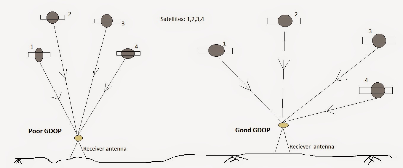
Fig: Satellite Geometric Dilution Precision (GDOP)
The presence of obstacles such as buildings, nearby
mountains can also alter the effective DOP value. It can also be represented as
HDOP, VDOP, PDOP and TDOP respectively for horizontal, vertical positional (3D)
and temporal dilution of precision. GPS receiver is able to obtain the DOP
value when taking measurements.
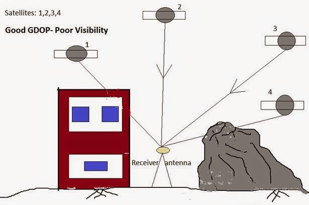
Fig: Good GDOP with obstacles
Thus the
higher DOP values introduces error in
measured coordinates, and represents the weak satellite geometry thus
the weak signals, also closely spaced satellites have low coverage of area
under observation so may introduce positional error too in DGPS surveys.
The geometry of satellites introduces the
positional errors, which called geometric dilution of precision and it can be
denoted as
GDOP= positional error/ range error
For assessing the error introduced by satellite
geometry let us take an example of 4satellite geometry which forms the
tetrahedron. The larger the volume acquired by tetrahedron the better will be
the GDOP value obtained. If the volume is small then the GDOP value get worse.
Similarly larger the no of satellites better will be the obtained GDOP.
The description of some DOP values given below;
DOP=1; Ideal DOP value, gives highest possible confidence
level
DOP=1 to 2; Excellent DOP value, used in highly sensitive
position measurements
DOP=2 to 5; Good DOP,
DOP=5 to 10; Moderate DOP,
DOP=10 to 20; Fair DOP,
DOP>20; Poor DOP,
User Equivalent Range Error (UERE):
User equivalent range error is a commutative effect
of various errors associated with the receiver and satellites, which is
contributing in the total error budget. It can be define as a equivalent error
in the range between the satellite and receiver. It can be introduced by
different sources thus independent of each other. The UERE can be calculated by taking square
root of the sum of the squares of all the errors. Their errors can be listed as
their descending order of contribution to the total error budget, as follow:
1.
Satellite
clock error: actually receivers are used in calculating the distance between
satellite and receiver position as function of time difference in signals, when
signal transmitted from satellite to receiver on ground. NAVSTAR satellite
clocks (atomic clocks) are very accurate, the possibility of their stray-up
from standard GPS time is negligible or of the order of milliseconds. And the
amount of satellite drift is calculated in the GPS control segment, generally
called monitoring station. Satellites
which are able to make clock correction, reduces the satellite clock errors
significantly.
2.
Upper
atmosphere (Ionospheric error): the atmosphere has varying density by latitude
all through the length of 50km to 1000km in atmosphere above the earth surface,
seasonally and with time also, due to these variation in density signals
propagating through atmosphere undergo various interference like delay in
signal propagation from satellite to receiver and also signal may get deflected
through their actual path. Satellite orbited vary close to the horizon, has
tendency to transmit a signal by taking a long route through the ionosphere
than the satellites overhead, so these signals greatly affected by
interference. The ionosphere's
density in response to the Sun's ultraviolet radiation, solar storms and
maximums, and the stratification of the ionosphere itself. The GPS Control
Segment is able to model ionospheric biases, however. Monitoring stations
transmit corrections to the NAVSTAR satellites, which then broadcast the
corrections along with the GPS signal. Such corrections eliminate only about
three-quarters of the bias, however, leaving the ionosphere the second largest
contributor to the GPS error budget.
3.
Receiver
clock error: Surveying receivers are equipped with the quartz crystal clock
whereas, NAVSTAR satellites have atomic clock. Quartz crystal clocks are less
stable than that of atomic clocks, thus due to the un-stability in time
measurement by the quartz clock some error introduced in the receiver
co-ordinates observed.
4.
Satellite
orbit: the shape of orbit of satellite is greatly affected by the gravitational
attraction of earth, sun and moon, the monitoring station calculates the
deviation in the in satellite eccentricities by observing the satellite
location in orbit and calculating the eccentricities of orbits. The deviations
are documented as ephemerids. An ephemeris is compiled for each
satellite and broadcast with the satellite signal. GPS receivers that are able
to process ephemerides can compensate for some orbital errors.
5.
Lower
atmosphere (Topospheric error): The atmospheric delays in GPS signals
are also adding slightly to the calculated distances between satellites and
receivers. Satellites close to the horizon transmit signals having mostly
delayed, since they pass through more atmosphere than signals from satellites overhead.
6.
Multipath
error: physical bodies obstruct the signals propagating through atmosphere,
thus introduces the error of multipath.
No comments:
Post a Comment