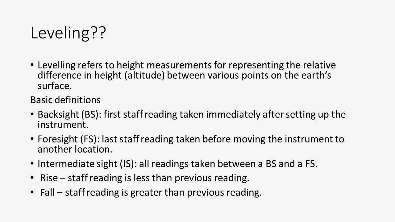
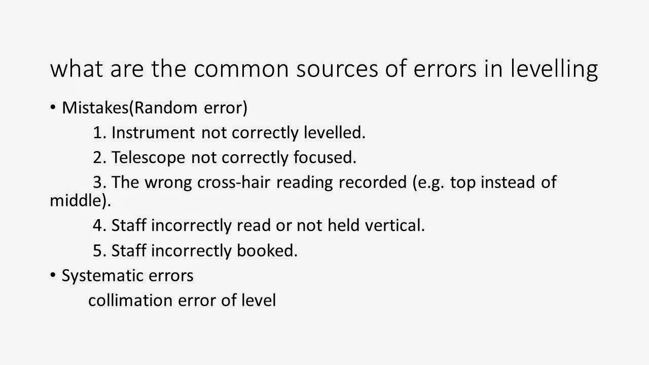
GPS Survey Methods
Contains:
Single Point or Point Vs
Relative, Static Vs Kinematic, Real time Vs Post mission,
Practical GPS survey field procedures: Code- and
Carrier-based positioning, Accuracy and recording time, Preparation of GPS
surveys: Setting up an observation plan, Practical
aspects of field observations, Observation strategies, Network design
1. GPS Positioning modes:
Point positioning:
It is an absolute mode of positioning, in which a single point has well defined
co-ordinates with respect to pre-defined global reference system.
Relative positioning:
In this mode of positioning observer takes a reference from different point.
The co-ordinates of a point are defined with respect to a known co-ordinate
point. Relative positioning is also known as base line determination in GPS
surveying. It is a differential type of positioning.
Static positioning:
coordinates of a stationary point in absolute or relative mode.
Kinematic positioning:
coordinates of a moving point in absolute or relative mode. Relative
positioning can be taken either in real time or post mission modes.
2. Real time Vs Post mission:
Real time mode of positioning somewhat related to the near
line site conditions, whereas post mission mode allows users to get sub meter
positioning up to 300km and mostly used for GIS applications.
Real time processing:
A.
Positions are computed almost instantaneously,
on site. No post processing is required and positioning results are instantly
available. There are two modes for such positioning- real time code RT-DGPS (code
based) and real time phase RTK (phase based).
B.
It needs a data link to transmit corrections
from a monitor receiver at a known point to rover receiver at unknown point
Post-mission
processing:
A.
GPS data is combined and reduced after all data
collection has been completed.
B.
It requires post processing of combination of
data from all receivers after an observation period.
3. Positioning using GPS
Absolute positioning:
A single passive receiver is used at a one station location to collect
the data from multi-satellites in order to determine the station location. It
is not useful in precise GPS surveying due to less accurate data received,
however it is most widely used in military and commercial GPS positioning
system for real time navigation and location determination. The accuracies of
poisoning is manly dependent on the user’s authorization. GPS point positioning
is also known as stand-alone or autonomous type of positioning which involves a
single GPS receiver. It can be
determined by the carrier-phase range measurements or code range measurements.
GPS receiver tracks at a time more than 4 satellites to determine its own
position coordinates.
A standard Positioning Services SPS) can achieve a real time
positional accuracies of 25m without selective availability. The lower level
accuracies using SPS is due to intentional degradation of GPS signal by the
selective availability. The Precise Positioning Services (PPS) user with a
receiver capable of tracking P-code, can a decryption device to achieve a point
positional accuracy in the range of 10-12m with a single frequency receive. To
get accuracies less than and equal to 1m, special equipment are required with
post processing techniques.
Absolute positioning can be sub-divided into following
categories;
1.
Absolute positioning using carrier phase
2.
Absolute positioning using C/A-code
(pseudo-range)
Absolute
positioning using carrier phase
A GPS receiver which is capable of receiving both the
C/A-code and carrier-phase is used to collect the positional information. By
using broadcast ephemeris, the user is able to use pseudo-range values in real
time to determine absolute point positions with an accuracy of 3m in the best
conditions and 25 m in the worst condition. Post processing technique can be
used to enhance the accuracy level which can be raise up to sub-meter level in
best condition and 15m in worst conditions.
Absolute
positioning using C/A-code (pseudo-range)
It is used for navigation purpose. When a GPS user perform a
navigation solution using C/A-code than an approximate range or pseudo range is
measured. Satellite position and range are very important parameters which
should be known when determining the precise location. Application of pseudo
range is to measure approximate distance between GPS antenna and satellite by
correlation of satellite transmitted code and reference code created by receiver,
without any error correction in synchronization between the clock of the
transmitter and that of the receiver.
The traveled distance by a signal can be measured by multiplying the
velocity of transmission of its satellite to elapsed time of transmission, with
the tropospheric and ionospheric effects are accounted. The accuracy of
positioning is a function of range measurement, and geometry of satellite. The
geometrical magnification of uncertainty in a GPS point positioning can be
describe by Dilution of Precision (DOP). For improvement of GPS range accuracy
repeated and redundant range observation must be taken, however DOP remains
same.
In a static mode, range measurement may be continuously re-measured
over varying orbital locations of satellites. Different satellites orbits cause
different positional intersection geometry.
At least four pseudo-range observations must be taken to
resolve a 3D GPS position. Only three pseudo-range observations are required
for 2D GPS position. In practice more than four observation are taken. To
resolve the clock biases contained in both satellite and ground receiver, more
pseudo ranges are needed.
Accuracy
and recording time:
Accuracy of GPS observations can be
varying from some meter level to sub centimeter level, depending upon the
method of GPS survey adopted and capability of GPS receiver used, and also for
the type of uses whether it is used for military purpose or civilian use,
accuracy differs.
Lower the recording time, higher
will be the data recorded which will boost the accuracy of observation so
generally it is kept 1seconds. But lower recording time increases the memory
uses also hence some time it causes trouble,
The main factors affecting the
accuracy of GPS observation can be listed as below;
1.
Biases and measurement errors
2.
Mode of positioning whether absolute
or differential positioning mode
3.
Geometry of satellite and receiver
4.
Pre and post processing algorithms,
operational modes, and others
Accuracy
and precision: it is referred to the closeness of
observation to the real value. Precision referred to the closeness of repeated
observation to the mean value of a group of observation sample.
Biases:
These are the systematic errors, which are responsible for the change in the
true measurements from the observed value by a constant amount, in a
predictable and systematic manner.
DOP
(Dilution of Precision); in case of navigation application, the
effect of satellite configuration geometry is expressed by DOP. It is a ratio
of the positioning accuracy to the measurement accuracy.
Biases
and measurement errors: All GPS measurements (pseudo range,
carrier phase, Doppler frequency) are very sensitive to the biases and errors,
their combined effect alters the positioning results. For high accuracy work
biases must be accounted in processing step of GPS data processing. Sources of
biases may be grouped depending upon their characteristics such as magnitude,
periodicity, satellite and receiver dependencies. Manly biases can introduced
by physical bases such as atmospheric effects and signal propagation, but they
can also introduced in the data processing stage due to poor knowledge of fixed
constants (like satellite orbit, station coordinates, velocity of light) to the
user. By considering errors we can consider the biases, which are correlated in
space and time. .
Mode
of positioning: Both the mode of positioning,
absolute or point positioning and relative positioning, are fundamental to
consideration of error /biases in GPS results and the datum to which the GPS
results relate. Point positioning with respect to well defined coordinate
system (WGS84 Cartesian reference system). This coordinate system is direct
realized to the monitoring station coordinates and subsequently transferred to
the users via the coordinates of the GPS satellite. As the satellite
coordinates are the key of computation of user position, any error or biases in
these coordinates will directly affects the accuracy and precision of results.
Higher accuracies can be obtained by
the relative positioning mode using the two receiver at different positions,
tracing the same satellites, because many errors will affect the absolute
positioning of two GPS receivers almost to the same extent which will be
subtracted in differential or relative positioning mode.
Geometry
of satellite and receiver: Accuracy of satellite measurements
is also a function of satellite-receiver geometry. Lesser the DOP, value higher
will be the accuracy of GPS observations and errors associated with
measurements are not so much amplified.
Higher values of DOP makes the position a point too much unreliable,
called outage. DOP varies with time and geography of an area, although for same
area it is same in ideal condition. DOP plays a vital role in point
positioning, although its role is limited in the relative positioning.

Pre
and post processing algorithms, operational modes, and others:
accuracy is also dependent on
a.
Whether the user is stationary or
moving condition, repeated observations are taken in stationary operation of
receiver which gives higher accuracy.
b.
Whether the results are in real time
or post processing, post processing improves the accuracy of results by
removing or lowering the errors associated.
c.
The level of measurement noise
considerably affects the accuracy.
d.
Degree of redundancy in measurements
e.
Algorithm type used in processing of
data
Preparation
of GPS surveys
Setting
up an observation plan: As long as
the GPS system was not yet complete, a pre-computation of coverage was an
indispensable preparatory step in project planning. With the system completely
deployed in 1995, sufficient satellites are visible above the horizon at any
time; hence field campaigns can be planned independently of the constellation.
For analysis purposes, and for kinematic observations, a pre-computation of the
satellite constellation can still be of importance.
These so-called
ALERT-lists can be computed with data from the satellite almanac. Almanac data,
that is, low accuracy orbit data for all available satellites, are transmitted
in the fourth and fifth subframes of the navigation message. These subframes
have 25 “pages” each 30 seconds long, so that the complete almanac information
can be read in 12.5 minutes.
With the aid of the
almanac data, satellite positions can be precomputed over several months with
sufficient accuracy for planning purposes. One must, however, occasionally
expect larger orbit maneuvers, so that a regular check of the almanac data is
recommended. With the almanac data, visibility diagrams and PDOP values can be
generated. Most manufacturers provides suitable software packages (mission
planning software) on a PC basis. The almanac data are available from various
internet sources,
Practical
aspects of field observations:
Firs essential step which should be
considered by a GPS surveyor is local reconnaissance in advance for taking
successful observations on field.
The site selection is a prime
concerned for surveyor, the visibility between two stations must be there for
setting out of a base line and site should be accessible for surveyor and
vehicles along them.
It should be kept in mind as a
general rule, that a free line of sight down to the horizon must be created in
all directions.
In a forested areas or
near buildings, a satellite visibility diagram ( sky plot, cf, fig.2) helps in
the site selection.
If the site is kept same for later
observation purpose, with the different satellite constellation, it is
recommended that horizon kept open at least down to a 100 elevation angle. For price surveying
work, height determination is advantageous for observations down to 50 for
price height.
If there is any obstructions at the
site, they must be documented, when reconnaissance survey is done in
reconnaissance sheet in a shadow diagram.
The GPS surveying technique is far
better than the conventional surveying technique such as triangulation, the
selection of GCP’s is more flexible than classical triangulation approach. It
permits somewhat flexibility in selection and requirement of GCP’s. The ground
control points need not to be inter-visible so there is no requirement of
setting them on topographic elevations or towers but only they should be
minimally obstructed and easily accessible.
The selection of GCPs must be
avoided (or not suitable) near the high buildings, power lines, towers,
transmitting antennas etc because of the introduction of multipath errors.
Receiver antennas must be kept very
high in wooded areas, can be mounted on light masts.
Centering and plumbing of GPS rover must
be done precisely so that GPS measurement evaluation is accurate and required
accuracy can be achieved, however in case of non-centeric observation required accuracy diminishes. Note that eccentricity calculation have to be done in 3D
space
In case of Follow-up survey with
electronic tacheometers, GCPs should be selected so a free sight is available
to nearby station mark or an inter-visibility lie between two GCPs installed a
few hundred meters away.
Generally survey station are decided
by the mapping and responsible surveying authorities. For surveys seeking for
high accuracy, the installation of stations must be done on stable ground
possibly on rock or concrete blocks.
The station mark can be used as
exact vertical reference so sufficient depth of foundation must be provided.
All essential
information should be documented in a reconnaissance sheet, possible elements
are,
1.
Station name and
identification code
2.
Description of site
3.
Approximate
coordinates and height
4.
Accessibility(car,
road condition, walking distance)
5.
Necessary antenna
height(tripod, mast)
6.
Orientation marks
7.
Shadow diagram
It is essential to check the
batteries of receiver and rover every day, although power supply is not a
issue, because of long lasting batteries in these days.
Newer version of receiver are so
designed that no requirement of skilled workers, however for standard operation
work and for precision skills are necessary. The
personnel operating the GPS,
should be capable of following:
1.
Mounting the tripod on
the station mark
2.
Measuring the antenna
height
3.
Controlling the
receiver operation
4.
Complete the work
according to a given time
5.
Run the station
control sheet
6.
Measuring additional
data if required
After completion of survey, GPS data must be downloaded and
stored in an appropriate recording device for further analyzing and processing
of data. Data download can be done once or twice a day, depending upon memory
capacity and amount of data stored. Modern receiver
hav built in solid state memories or plug in memory cards.
Observation
strategies: Two observation strategies can be
follow in any GPS surveying;
1.
Some of the main sites
should observe during at least one 5 to 7 hours session during one single
working day. Whereas remaining sites may observed in quasi-continuous manner.
2.
All the base lines may
be chosen so as to minimize their length, to minimize common observations
between stations and to avoid receiver and antenna type mixing.
3.
Generally, the
collected GPS data were processed on the daily basis and cleaned for cycle
slips automatically in most cases and manually whenever required in order to
ensure the reliability of the results (Tomae and Tsagannidou, 1998).
(Reference:The Adria Microplate: GPS Geodesy, Tectonics, and Hazard... Edited By Nicolas Pinter)
Network
design: It a most important aspect of
surveying. The final network design or project design refer to a compromise in
the technical requirements as well as economics, which is carried out within
the framework of explicit recommended practices for GPS surveys.
The surveyor must kept in mind when
designing a network;
1.
Definition of network, it means size
and shape of network, required GCPs, number of stations and spacing between
them, inter-visibility if any requirement is there.
2.
Spacing of exiting known stations
3.
Accuracy requirements and
standards
(Reference: Global Navigation Satellite System By Rao)
Generally GPS stations forms a
cluster of points around the project area for example roads, dams etc.
This clustering provides the
surveyor, a good traditional geodetic control over an area but generally main
stations marks are evenly spaced, and located at prominent locations, such as
hill top, so that inter-visibility can be assured between two station marks.
Extra control over nearby geodetic area is not required in the GPS surveys.
Hence the Importance of even spacing of stations and selection on the basis of
terrain profile, no longer plays a vital role.
Once the number of total station
decided, and also the approximate location of these station, some of the
important points must be consider;
1.
There should be some inter-visible
stations to the azimuth in starting of survey without disturbing the original
network design.
2.
Depending upon the terrain, some
reference marks must be set up. The distance may be taken in the range of
couple of hundred.
3.
Some existing stations if there in
site area, may be included in survey which can be used to ensure datum
definition or calibration of GPS heights.